El Niño, aka “The Niño”, is a naturally occurring, periodic warming of the eastern and central Pacific waters. El Niños, especially strong ones, get a lot of attention because they alter large-scale atmospheric circulations that affect storm tracks across North America, monsoon rains in Asia, and tropical cyclones in the Atlantic and Pacific.
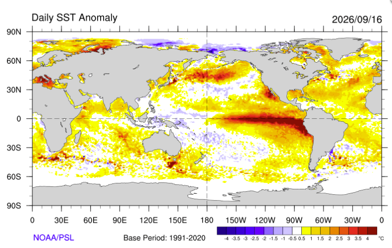
Perform a Google search “El Niño Impacts” and the top non-map images include: a barren desert with thirsty cattle, some sort of decrepit virus looking planet with dead trees, a second ground-level desert image with a blazing sun setting in the background, a river overflowing its banks, and a blazing rain forest fire. No wonder El Niño doesn’t get a fair shake with public perception. Why does El Niño cause media channels to light up with end times messages of drought, flooding, and fire? Let’s try to shed a little light on the matter.
What Causes El Niño?
El Niño is caused by a feedback loop involving two ingredients: internal ocean waves and tropical trade winds. Internal ocean waves develop and move below the ocean surface. They are caused by some kind of surface disturbance, perhaps a large burst of wind or strong thunderstorms, that perturb the upper ocean. Such a disturbance may create two waves: an eastward-moving “Kelvin Wave” that travels relatively quickly and carries high amounts of energy (i.e. warm water) toward the cold eastern Pacific, and two westward-moving “Rossby Waves” that transport relatively cooler water toward the western part of the basin.
Both Kelvin and Rossby waves are constantly moving across the basin at diverse speeds, intensity, and numbers. If more high energy Kelvin waves dominate, then the eastern and central Pacific will begin to see a slight warming. This is where the atmosphere kicks in. Normally, very strong tropical winds (“trade winds”) blow from the cold eastern Pacific to the warm western Pacific. These winds literally keep the very warm Pacific waters in the west and also encourage subsurface water to move upward (“upwelling”) in the east, creating a cold surface pool.
When the ocean begins to warm the east, the difference in ocean temperatures across the basin shrinks and the trade winds begin to weaken. Upwelling in the east becomes weak, and warm water in the west begins to work its way eastward. If the process continues and enough warm water develops, we have an El Niño on our hands.
Why do we care about El Niños?
The amount of energy that gets moved around is massive and causes changes in the atmospheric circulation both inside and outside of the Pacific Basin. Air that normally rises in the western Pacific – creating thunderstorms – shifts eastward, frequently bringing drought conditions to northern Australia, Indonesia, and southeast Asia. Conversely, normally dry areas in western South America can experience substantial rainfall.
Tropical cyclones thrive in the eastern and central Pacific, feeding off of the warmer water. However, there is usually much less activity in the North Atlantic. The new atmospheric circulation tends to rip apart developing hurricanes before they can get going. Finally, El Niño affects much of the United States, especially in the wintertime. The southwest and southeast are typically much wetter as storm tracks shift over those areas. Most of the northern half of North America experiences a warmer and usually drier winter. In total, EN potentially can affect billions of people, exposing them to cycles of drought, flood, or unusual weather.
Types of El Niños
Not all El Niños are the same. In the last couple of decades, scientists have explored two different “flavors” of the event. They found that each flavor produced a unique set of impacts outside of the Pacific.
The location of the warmest water dictates the flavor of the event. An “EP” event is one where the warmest water forms in the eastern Pacific. Sometimes the peak warming will occur closer to the international date line; that flavor is labeled a CP event. The figure below shows the different sea surface temperature patterns for each flavor.
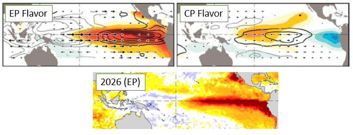
EP events have the following characteristics: higher precipitation for India and Australia (i.e., less risk of drought), lower frequency of North Atlantic tropical cyclones, and higher intensity rainfall in the eastern Pacific – including parts of Ecuador and Peru.
The historically strong 2026-27 EN is an EP event. It has absolutely squashed the North Atlantic hurricane season, which will not see a hurricane into late September.
CP events create the most devastating droughts in the western region, including India and Australia. Interestingly, CP events have been connected to increased frequency of North Atlantic tropical cyclones with higher risks of landfall along the Gulf coast and Central America. A good example of this is the 2005 Atlantic hurricane season, which saw a record 27 tropical storms and hurricanes despite the existence of a CP El Niño.
El Niño Dissipation
Inevitably, El Niños weaken, eventually giving way to their opposite phase, “La Niña”. The same internal ocean waves that brought the warm water into the east now work in the opposite direction, redistributing cooler eastern Pacific waters to the western part of the basin. Once surface temperatures begin to modify, the atmosphere responds and the trade winds intensify. Upwelling regenerates and colder subsurface waters appear again. The whole cycle can take anywhere from 2-7 years. CP events are usually more transient (2-3 years), while EP events cycle through at longer periods.
El Niño Forecasting
ENSO is one of the most important predictors used in long-term (seasonal) forecasting. There are a couple of reasons for this. First, an ENSO cycle lasts several years; in other words, there is a lot of persistence in the system. If the system changes slowly, it is easier to make skillful forecasts out to longer time periods. Second, the impacts from ENSO are reliable. Thus, if we can skillfully predict the phase of the ocean, we can also reliably predict the impacts in many areas of the world.
Unlike daily weather – where good forecasts can be made only about a week in advance – meteorologists can skillfully forecast El Niños and La Niñas out to several months. This is possible through monitoring sea surface temperature trends and tracking internal ocean waves using satellites and buoys.
Don’t Fear El Niño, You’ll Be Fine!
The media needs your attention; El Niño is a perfect conduit for grabbing it. The 2026-2027 El Niño event is everywhere because it’s especially strong, and might be the strongest in the known record. But don’t fall for the fear trap. El Niño impacts for a specific location cannot be determined solely by how warm the ocean water gets. The Earth’s ocean-atmosphere system is incredibly complex. There are many other drivers of weather and climate that enhance – but also counterbalance – El Niño’s effects.
So please, tune out the big red maps, the screaming headlines, the dire predictions that hell on earth is about to break out this winter. Even if that were to come true, there’s nothing you can do about it. Focus on things in your personal sphere of influence: friends, family, your health, and doing positive things. There will always be more El Niños and yes, there could be negative experiences for many people. We can have empathy for those affected and be free from fear; these are not mutually exclusive.
Sources
Capotondi, A., and co-authors, 2015: Understanding ENSO Diversity. Available at https://doi.org/10.1175/BAMS-D-13-00117.1)
IBS Center for Climate Physics, accessed 2026: https://ibsclimate.org/research-news/the-blueprint-for-el-niño-diversity/
Physical Sciences Laboratory, accessed 2026: Current SST Conditions, https://psl.noaa.gov/enso/current.html
Dr. Chris Hennon is the Founder and Lead Consultant for Hennon Weather Services LLC. He is a Certified Consulting Meteorologist and former Professor of Atmospheric Science with expertise in Tropical Meteorology and Weather Forecasting.