It’s mid-November 2026 and the headlines are everywhere:
“Record-early weak polar vortex could chill US by Thanksgiving week” – The Weather Channel
“This winter, it’s polar vortex versus El Niño – Round one starts now” – CNN
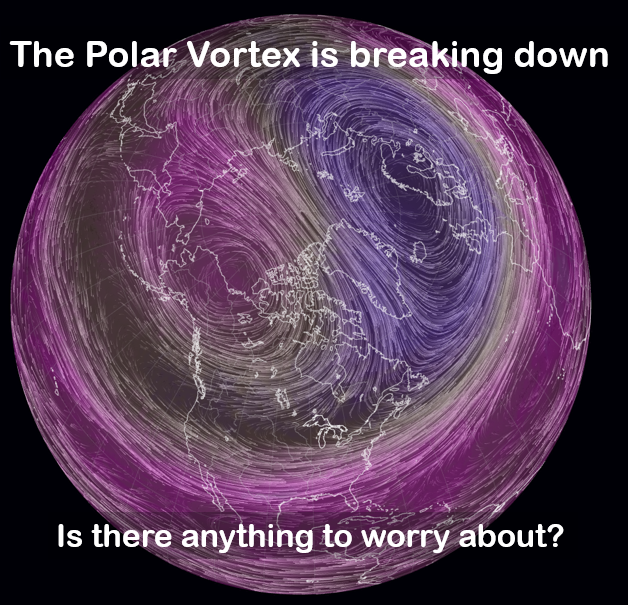
It’s seeming like this Polar Vortex guy is causing some trouble. But what exactly is it? Does it bring us weather worthy of national headlines? Or is this typical mainstream media hyperbole? Let’s take a look.
What is the Polar Vortex?
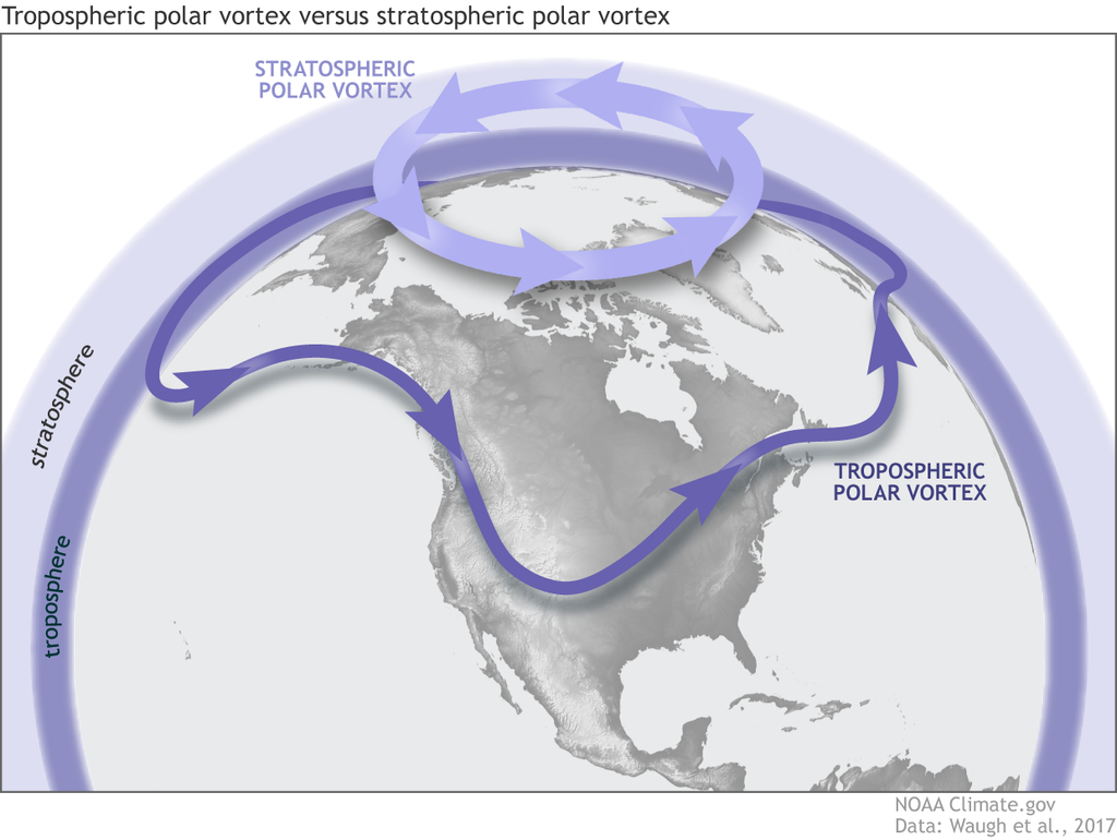
The polar vortex is a band of wintertime, high-speed (up to 250 mph) winds at Arctic latitudes that usually flow from west to east. It’s important to note that these winds are in the Earth’s stratosphere, which occur at heights above where commercial jets fly – generally between 35,000 and 160,000 feet above the ground. The polar vortex is not the same thing as a jet stream. A jet stream is a strong current of west to east wind, but it is located lower in the atmosphere between 25,000-35,000 feet above the surface.
Why does the Polar Vortex exist?
Winds in the atmosphere are produced by pressure differences. That’s why weather systems like hurricanes and tornadoes produce such strong winds; they have much lower pressure than the surrounding atmosphere, so air ‘rushes in’ to fill the void. The polar vortex is different because the winds are flowing at a much larger scale. It isn’t a weather system per se – we can call it a global circulation.
An imbalance in temperature creates pressure differences. When the atmosphere is warm, the air takes up a larger volume, making the atmosphere thicker. When the air is cold, the air fills a smaller space and the atmosphere is thinner.
It’s easiest to imagine the atmosphere as a series of peaks (warm, thick) and valleys (cold, thin). If you’re halfway up a peak and let gravity do its thing, which direction will you go? Down the slope, of course. The bigger the difference in temperature – or, the more altitude changes over a given distance – the faster the winds will flow.
In the summer, the difference in temperature between the low latitudes (i.e., tropics) and high latitudes (Arctic) are more subtle – the ‘slopes’ are gentle. The polar vortex disappears. In the winter, the temperature changes rapidly from south to north. Big peaks and valleys mean a strong polar vortex.
How does the Polar Vortex affect weather in the United States?
The mainstream belief is that a weak polar vortex will generally lead to cold air outbreaks in the U.S., bringing frigid temperatures and stormy conditions. This can certainly occur but it is important to understand why this belief exists and why it is not always the case.
Remember, our weather at the surface is occurring well below the stratosphere. Mid-latitude storms, weather fronts, thunderstorms, and temperature extremes are phenomena driven by circulations from the surface up to the top of what’s called the troposphere (which sits below the stratosphere). Since the polar vortex is a stratospheric phenomenon, it does not directly affect our temperature or storminess.
However, there are indirect connections between the polar vortex and surface weather. Our weather is very much influenced by the strength and position of the jet stream. Recall that the jet stream is a fast current of air well below the height of the polar vortex. The position and strength of the jet stream directly control where storms will form and move and which places will be warm or cold. A west-east oriented jet stream will bring quiet conditions; a wavy jet will bring periods of stormy conditions with frequent warm and cold air surges.
The polar vortex appears to have an influence on the nature of the jet stream. When the vortex is strong, the jet stream tends to be less wavy and tethered to a more northerly latitude. This situation generally leads to calm and mild conditions for the USA. A weakened polar vortex leads to a more uncertain jet stream. The jet tends to become ‘wavier’ and may even break up into several different pieces. A wavy jet will bring more extreme temperature changes and more frequent storms. Also, the jet stream will tend to move southwards, opening a gateway for Arctic air to move into the United States.
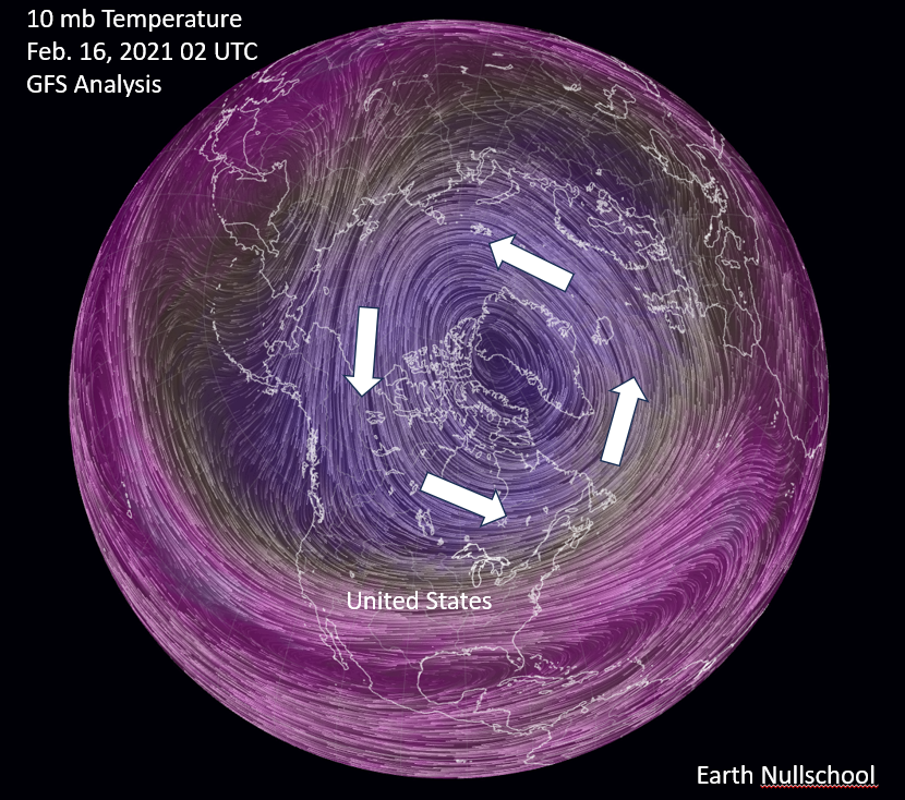
An example of a strong polar vortex looks like this:
The November 2026 Polar Vortex breakdown
What is happening in November 2026 with the polar vortex and why are we seeing provocative media headlines? Well, the polar vortex basically got sliced in half. Check out the image below and compare it to the ‘strong’ polar vortex above:
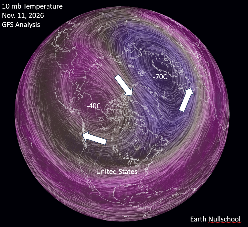
What happened? Recall that the strength and shape of the vortex are driven by the temperature field. Over northern Alaska and Canada, the air has quickly warmed over 30 degrees Celsius. This event is called a Sudden Stratospheric Warming event, or SSW. The result is that the stratospheric winds over Canada have now reversed direction, flowing east to west in a clockwise direction around the warmer air. The ‘normal’ portion of the polar vortex has shifted over Scandinavia.
The SSW and subsequent polar vortex breakdown are not unprecedented; they occur every other year or so. What is unusual about this one is the time of year that it occurred and its intensity. November is usually when the polar vortex is approaching full intensity after its dormant summer – not breaking down. It’s only happened a couple of times in November before since we’ve begun observing it.
What does this breakdown mean for us?
Most media will tell you that the compromised polar vortex is likely to bring cold and stormy weather to the U.S. – Arctic air is now free to break out of the vortex and invade! But for this particular event, there’s nothing in the near-term objective weather forecasts that suggest this will be the case. In fact, all of the Climate Prediction Center temperature outlooks are showing above average temperatures for the eastern half of the U.S. for the remainder of November. Thanksgiving looks like a normal or mild one for much of the country.
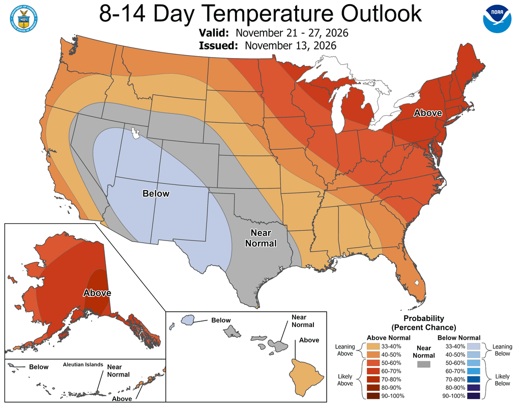
The temperature pattern above is more indicative of a strong El Niño than a weak polar vortex. So, if we buy in to the CNN headline of ‘Polar Vortex vs. El Niño’, it looks like a clear winner is emerging.
Conclusion
The term ‘polar vortex’ has been around in the scientific literature for decades. It wasn’t until the Arctic air outbreak in January 2014 that it became part of the public vocabulary. That one looked like this:
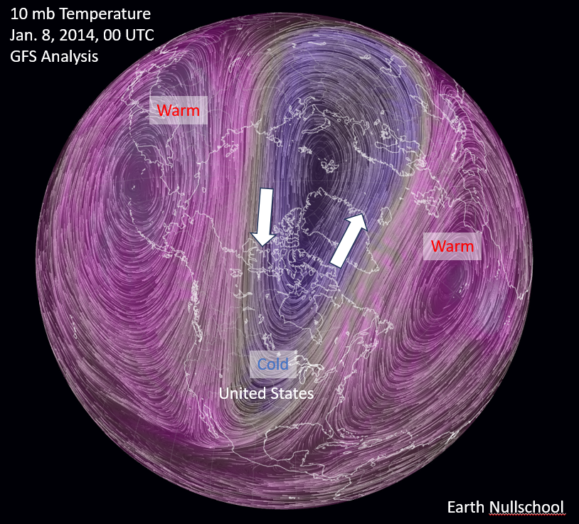
Notice any differences than the November 2026 case? This one sure looks like a strong polar vortex. However, it isn’t circular, and its lobes stretched just far enough in one direction to influence our jet stream to dive down into the southern plains. This brought frigid temperatures all the way down to the Gulf coast. It is interesting that much of the Northern Hemisphere – especially Siberia and Europe – was experiencing unusually warm temperatures at this time.
With all that said, here are my three takeaways:
1. The polar vortex does not directly affect our weather. But it does have influence on the characteristics of the jet stream, which has direct influence.
2. When the polar vortex is weak, we are more likely to experience episodes of stormy and cold weather. But warm and dry conditions can happen as well, and maybe just as frequently.
3. The November 2026 breakdown is unusual for its timing and intensity. And yet, forecasts suggest that our weather will be mild during the event, at least for the next two weeks.
For an article with a bit more scientific depth, I highly recommend the source below!
Source
Waugh, D.W., A.H. Sobel, and L.M. Polvani, 2017: What is the Polar Vortex and how does it influence weather? Bulletin of the American Meteorological Society, Vol. 98, 37-44. https://doi.org/10.1175/BAMS-D-15-00212.1
Dr. Chris Hennon is the Founder and Lead Consultant for Hennon Weather Services LLC. He is a Certified Consulting Meteorologist and former Professor of Atmospheric Science with expertise in Tropical Meteorology and Weather Forecasting.